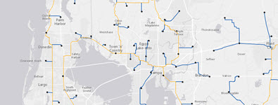
Telecommunications
Now you can wield that power to plan, build, and expand your network where customers need it most. Even more, analyze trends, communicate with potential customers, and design smart marketing campaigns. All this can be accomplished using ArcGIS— a complete technology platform and your work can be done from nearly anywhere and on pretty much any device.

Benefits
MARKET ANALYSIS
Revenue Forecasting; Determine market potential and identify high-revenue areas.
Business Intelligence; Boost your business intelligence with data on customers and competitors.
Campaign Management; Track customer connections, mix activity, and market trends within your service area.
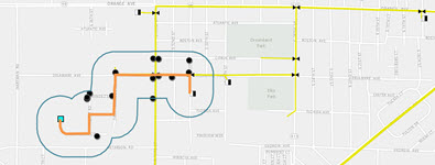
NETWORK PLANNING
Demand Forecast; Establish a correlation between network capital requirements and market revenue potential by service area.
Capacity Analysis; Monitor growth and expand capacity to reduce risk of held orders or denial of service.
Capital Efficiency; Plan your network expansion with fewer field visits.
ENGINEERING & CONSTRUCTION
Optimized Design; Integrate localized information to produce more precise designs with fewer delays.
Network Activation; Meet service commitment dates by tracking expansion & construction progress.
Contractor Management; Provide contractors accurate designs and monitor construction progress.
SALES & SERVICE DELIVERY
Serviceability; Identify opportunity areas, monitor network expansion, and determine accurate installation for new customers.
Installation Interval; Save the cost of a site visit with office access to data such as drop requirements and network capacity.
Revenue Analysis; Create an accurate model of true revenue potential for future expansions.
CUSTOMER CARE
Repeat Trouble Reports; Enable service technicians to generate repeat trouble reports.
Churn Reduction; Reduce mix up by mapping & evaluating disconnects for targeted retention programs.
Workforce Management; Allow dispatchers to process customer service requests and follow through.
Solutions

ArcGIS Online
Deploy real-time, interactive web maps to mobile devices and computers. Make maps without prior GIS training, and choose who gets to see which information. ArcGIS Online converts from any device, desktop, or browser.
Apps for Everyone
Series of tools and configurable web application templates to support telecommunications workflows.