Image Analysis with ENVI
Geospatial Imagery is used more and more across industries because it provides up-to-date, accurate information about geographic areas of interest. Because of this, you need advanced software technology that can effectively exploit the growing number of sensors and the increasingly large datasets they provide.
ENVI changes this paradigm by offering a complete suite of image processing and analysis tools that enable you to easily extract pertinent information from imagery without expending valuable time and effort learning advanced image analysis techniques.

THE PREMIER SOFTWARE FOR EXTRACTING INFORMATION FROM GEOSPATIAL DATA.
Modules
Quickly and easily perform tasks that require advanced image analysis tools.
ENVI FX (Feature Extraction) – find and extract objects based on the object’s spatial, spectral and texture characteristics.
ENVI DEM (Digital Elevation Model) – quickly and easily create spatially accurate digital elevation models.
ENVI Photogrammetry (Orthorectification) – register imagery to ground coordinates & geometrically correct them to remove distortions that happen during image capture.
Workflows
Guide you through advanced image analysis task.
Hyperspectral (Tactical Hyperspectral Operational Resource–THOR) – automated workflow designed to take advantage of hyperspectral imagery.
- Anomaly Detection
- Atmospheric Correction
- Change Detection
- Stressed Vegetation
- Target Detection
Multispectral (Spectral Processing Exploitation and Analysis Resource–SPEAR) – automated workflow designed to take advantage of multispectral imagery.
- Change Detection
- Detect Anomalies
- Terrain Based Orthorectification
- Register Images
- Pan-Sharpen Images
- Assess Vegetation Delineation
- Stress Detection
- Find Similar Materials
Automated Processing Tools – take the complexity out of popular image analysis task.
- Anomaly Detection
- Change Detection
- Seamless Mosaic
- Image Registration
- Feature Extraction
- Thematic Change
- Classification
- RPC Orthorectification
Benefits
IMAGERY BECOMES KNOWLEDGE
- Use one solution to work with all your data types
- Access a complete suite of analysis tools
- Customize to meet your project needs
ONE SOLUTION FOR ALL THE DATA TYPES
- Read and analyze different data formats.
- Fuse multiple data modalities.
- Exploit information from different sensor types.
- Easily process large data sets.
IMAGE ANALYSIS TOOLS
- Spectral analysis tools.
- Data analysis tools.
- Advanced image analysis tools.
- Extensibility – extend and customize features and functionality through an API.
Integration with your existing geospatial workflow
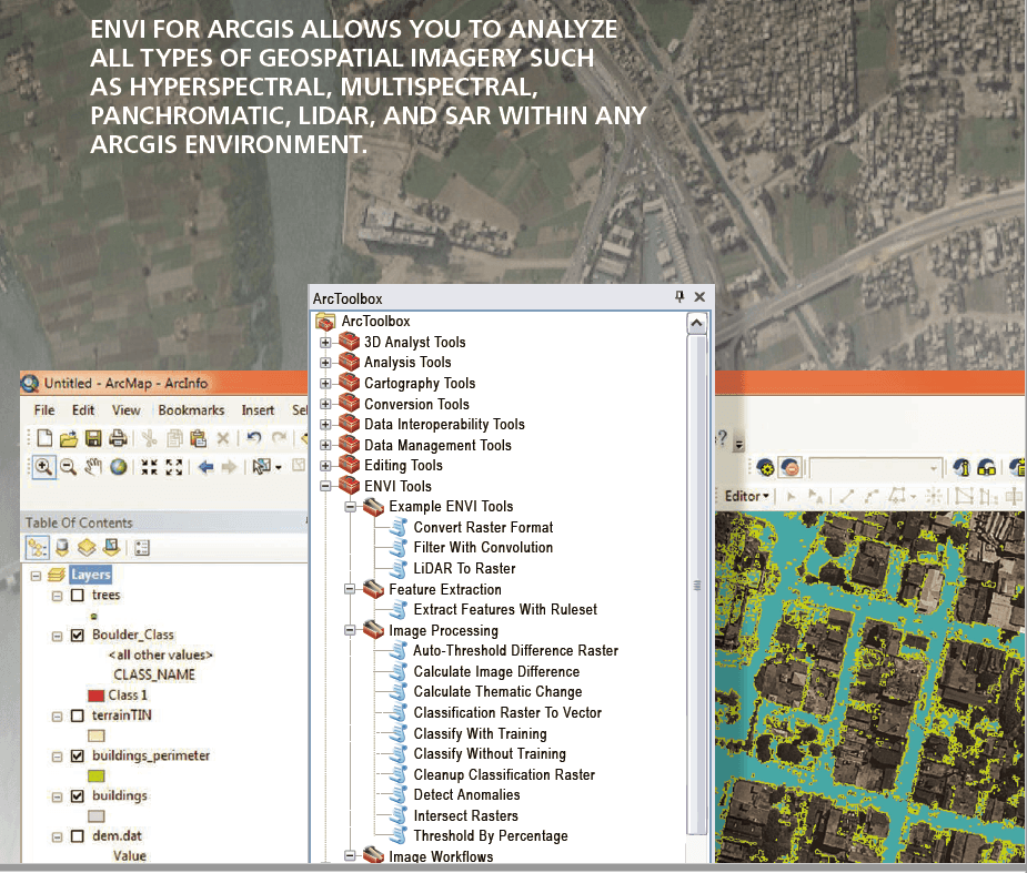
ENVI image analysis capabilities are fully integrated with ArcGIS® Platform from Esri, eliminating the need to switch between software packages.
You can easily access ENVI image analysis tools directly from the ArcGIS environment, send results from ENVI to a geodatabase, or push information from ENVI directly into ArcMap™.
LiDAR Analytics
What is ENVI LiDAR?
An interactive geospatial software environment that allows you to create powerful, realistic 3D visualizations and easily extract important features and products from LiDAR point cloud data.

WHAT IS LiDAR?
LiDAR (Light Detection and Ranging) is a remote sensing technology that uses light pulses to measure the distance between a sensor and reflecting objects such as the Earth’s surface, buildings, and trees.